
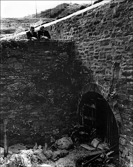
Site of entrance to Harford’s Tunnel, near Tredegar
Somewhere beneath this spot was the western entrance to Harford’s Tunnel. The tunnel was dug in the 1830s after a falling out between industrialists.
In 1794 Richard Fothergill and Rev Matthew Monkhouse took over the lease of the Sirhowy Ironworks. In 1800 they and Samuel Homfray built the Tredegar Ironworks, alongside Tredegar town. Their Sirhowy tramroad to Newport was completed in 1805. It cut the cost of transporting the output of both ironworks to market.
 Quaker banker John Harford and his older brother James owned the ironworks in Ebbw Vale. They obtained the Sirhowy lands shortly before the previous ironworks lease was about to expire in 1818. They offered the Sirhowy Ironworks owners a new lease for £2,500 but Richard Fothergill thought that was too expensive. After the threat of legal action, he had to relinquish the ironworks to the Harfords and their partners.
This caused irrevocable damage to their relationship. All connections were broken off between the Sirhowy and Tredegar ironworks. Richard Fothergill moved equipment from the Sirhowy to the Tredegar ironworks. Marker stones still exist along the river where boundaries were established between the rival works.
The Harfords greatly expanded the Sirhowy Ironworks but could no longer dispatch its iron on the Sirhowy tramroad. Initially they sent the iron via two tramroads to the canal head at Crumlin, where it was loaded onto boats for the last leg to Newport. This wasn't financially viable, so a tunnel was dug from here to the company’s furnace in Ebbw Vale.
Harford’s Tunnel was 2.4km (1.5 miles) long. It was walled and arched by the 1880s, when it was being used only occasionally to carry goods from Ebbw Vale to the Sirhowy Company shop. By then, local industries were connected by steam railways. Local residents would walk through the tunnel as a short cut between Tredegar and Ebbw Vale.
The exact location of the tunnel entrance – shown in the old photo – is unknown, as it was buried under shale and coal spoil in the 20th century.
With thanks to Kathryn Learwood
Grid reference: SO 14749 09838 View Location Map